Monday

Today's Rare Map: Town of Boston 1769

Map of Boston, dated 1769. Love the details in this one. This is a reproduction of a map described as: a new plan of ye great town of Boston in New England in America with the many additional buildings and new streets to the year, 1769; drawn by William Price.

From the largest and most comprehensive cartographic collection in the world.

Click here to view this map in detail.

Today's Rare Map: Old Antique map of Kazachstan, Oezbekistan and Turkmenistan, Georgia


Date: 1762, made in Paris.
Author: Bonne, R.

Rigobert Bonne (1727-1795), French cartographer. His maps are found in a.o. Atlas Moderne (1762), Raynal's Histoire Philos. du Commerce des Indes (1774) and Atlas Encyclopedique (1787-1788).A map centered on what is called on the map 'Tartarie Independante', the area east of the Caspian Sea with Kazachstan, Oezbekistan and Turkmenistan, also depicting Georgia and Iran.

Enjoy!

Click here to learn more about this amazing map.

Today's Rare Map: 1725 Map of Africa

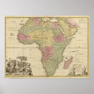
Vintage 1725 Africa Map: Africa, from the observations of the Royal Society.

Map by John Senex: Africa, corrected from the observations of the Royal Society at London and Paris. High Resolution image suitable for large or small copies.

John Senex (1678, London – buried 1740, London) was an English cartographer, engraver and explorer. He was also an astrologer, geologist to Queen Anne of Great Britain, editor and seller of antique maps and most importantly creator of the pocket-size map of the world.

He was in particular, one of the principal cartographers of the 18th century. He started his apprenticeship with Robert Clavell, at the Stationers Company, in 1692. Senex is famous for his maps of the world, some of which have added elevations, and which feature minuscule detailed engravings. Many of these maps can be found in museum collections; rarely, copies are available for private sale. Some copies are held in the National Maritime Museum; many of his maps are now in the possession of Trinity College Dublin. Having worked and collaborated with Charles Price, Senex created a series of engravings for the London Almanacs and in 1714 he published together with Maxwell an English Atlas. In 1719 he published a miniature edition of Brittania by Ogilby. He became particularly interested in depicting California as an island instead of part of mainland North America, a trait which makes many of his maps appealing to collectors. In 1721 he published a new general atlas.

In 1728 Senex was elected into the Fellowship of the Royal Society of London.

Enjoy!


Today's Rare Map: Michigan 1853

This is a vintage map of Michigan produced in 1853. Love the unusual pastel colors used for the counties.


Today's Rare Map: Asia 1789


Asia. Divided into its Principal States and Regions; with All The Islands and The New Discoveries made by the English, and the Russians in The Eastern Parts.


London: Printed for Robert Sayer. Jan. 1789 Price: U.S.$425

Hand-coloured map in outline, 450 x 335mm., showing splits at central fold, slight offsetting from being folded, a good copy of an attractive 18th century map.

Click here to learn more about this map!